A series of isolated chambers lay very near the
surface of Mu
and their bolstering gases were upholding her.
The
next line of chambers were many miles below.

Conditions of the Earth before Land appeared

The probable Condition underlying Mu before her Submersion

Probable Position of Gas Chambers underlying Mu before Her
Submersion

Present Gas Belts Across and Around the Pacific Ocean.

THE GREAT CENTRAL GAS BELT

COL. JAMES CHURCHWARD
NOTE FROM JEFF: Lemuria, or 'Mu', was a quasi-mythological continent located in the centre of the Pacific Ocean. The story goes that she sank tens of thousands of years ago, in a matter analogous to Atlantis, which was in the Atlantic ocean. Churchward reckons that both continents sank because of the collapse of subterranean gas chambers. This is very interesting food for thought relating to what is happening around the world today: giant sink-holes opening up and swallowing towns, methane volcanos erupting out the oceans, anomalous earth-quake activity globally. The Earth has always been a living, growing and evolving dynamic being LONG before the advent of human presence or 'civilization.' Our knowledge of the Earth is scant, and modern geology is riddled with realizations that fly in the face of mainstream belief, for example, the hypotheses of the 'expanding Earth', 'abiogenic petroleum', and telluric currents in the Earth's crust that function as her nervous system impulses. Add in the ever-growing impacts of military-industrial war on the Earth...mining, hydro-carbon exploration and extraction, contamination by chemical, nuclear and electromagnetic wastes and technologies, geo-engineering, environmental modification...and it's clear that our 'technogeneous' intrusions are disrupting, interfering with and exacerbating 'natural' cycles and processes which in themselves have been catastrophic for life as we know her. Churchward should be read along with Immanuel Velikovsky's Worlds in Collision and Earth in Upheaval to form a clearer picture of the true archaeo-geological 'big picture' we are living within.
'THE GEOLOGICAL HISTORY OF MU'
Chapter 13 from The Lost Continent of Mu, James Churchward, 1926
DOWNLOAD PDF OF BOOK:
DOWNLOAD OTHER CHURCHWARD BOOKS
'LEMURIA: ITS LAND AND PEOPLE' Shirley Andrews
'ATLANTIS IN THE CARIBBEAN' Shirley Andrews
After having read thus far, it will be of interest to learn the geological history of Mu and to know the scientific cause of her destruction.
I have already shown how the subterranean foundation of this vast continent was undermined by the volcanic gases. Granite, the primary rock in the formation of the earth's crust, appears to have been honeycombed with huge chambers and cavities and these were filled with highly explosive volcanic gases. When these chambers were emptied of their gases the supporting roofs caved in and the submersion of the land above logically followed.
My investigations have proved that the calamity which overtook this early civilization was due to the emptying of a series of isolated upper gas chambers that were upholding the land and which were probably connected with each other by cracks and fissures.
In order to make clear to the reader what I mean when referring to upper, middle and lower chambers and isolated chambers, I have made a sketch of groups of Archaean gas chambers, together with an explanation.
I have intentionally drawn the chambers higher than was
actually the case in order to emphasize them.
Sketch of Archaean Gas Chambers
Sketch of Archaean Gas Chambers
Fig. A. I here give the upper and
part of the second series, each division showing groups of chambers
at varying depths from the earth's surface. This sketch depicts a
somewhat similar condition to that which existed below the surface
of Mu before that ill-fated continent vanished forever beneath the
waters of the Pacific.
The upper series is given as being 15 miles
in depth, the middle series will be from 15 to 30 miles and the
lower series from 30 miles to the earth's molten center.
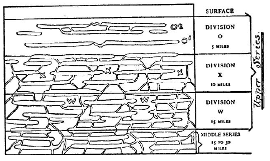
Fig. A. Conditions of the Earth before Land appeared
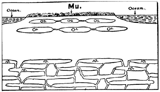
Fig. B. The probable Condition underlying Mu before her Submersion
Fig. B. The probable Condition underlying Mu before her Submersion
The upper series is arranged in three divisions (O, X and W].
Division O runs from the earth's surface down to a depth of 5 miles.
All chambers in this division are represented as being of the
isolated variety. By "isolated" I mean that they have no connections
with the chambers below, or with the earth's center, from which they
might obtain additional gases that would overcompress and blow them
out. As they stand, no new gases can be driven into them, and,
unless additional gases are forced into them, they will stand as
they are through all eternity.
Division X runs from 5 to 10 miles below the earth's surface. These are live chambers, constantly receiving from Division W fresh gases which pass from chamber to chamber through cracks and fissures.
To drive additional gases into the isolated chambers of Division O, volcanic workings must first open cracks and fissures from Chambers X to O [1] and then from O [1] to O [2].
Gases coming from the chambers of Division W, which are in communication with the earth's center, must first flow into Chambers X and overcompress them. This would necessitate the raising of the roofs of these chambers to make room for the new gases.
In raising the roofs, the rocks forming them would be split and fractured, forming passageways for gases from Chambers X into Chambers O [1]. In time Group O [1] would become overcompressed.
This would necessitate the raising of their roofs. Then the roofs of
Chambers "O" would have to be raised to accommodate the
ever-increasing pressure from new gases. Their roofs would go up,
split and be punctured by the gases, which in the form of volcanoes
would empty the chambers down to a point where the bolstering gases
could no longer uphold the roof. What would be the result?
Their
roofs would crash down to their floors, the remaining gases would
assume the form of huge flames and envelop the land as it went down.
The surrounding waters would flow into the enormous hole and the
land would be submerged.
Gas belts run at irregular depths below the earth's surface. From various observations of certain phenomena covering a period of over fifty years, I have come to the conclusion that, generally, the great gas belts have been forged along the upper half of the middle series and the lower parts of the upper series. Gas belts do not run at regular distances below the earth's surface, as I have indicated, but vary considerably. A section may run through Division W.
Gas belts run at irregular depths below the earth's surface. From various observations of certain phenomena covering a period of over fifty years, I have come to the conclusion that, generally, the great gas belts have been forged along the upper half of the middle series and the lower parts of the upper series. Gas belts do not run at regular distances below the earth's surface, as I have indicated, but vary considerably. A section may run through Division W.
The
next section may be through Division X and then back again into
Section W. In short stretches they come to within a mile or two of
the earth's surface. This happens most often when they are
approaching their safety valves, the volcanoes, as may be noted in
Hawaii, Ecuador, Central America, and several other locations. It is
safe to say that no belt runs below 20 miles from the earth's
surface, usually much less.
My observations lead me to believe that
their average depth is from 15 to 18 miles below the earth's
surface, except when they are approaching their volcanoes.
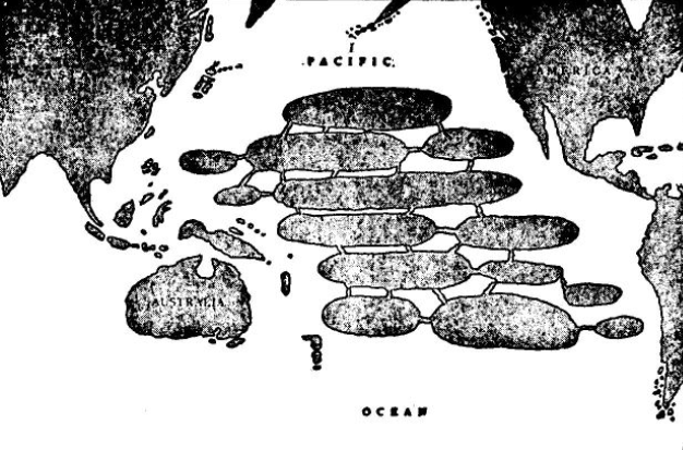
Fig. B
This shows the probable condition that underlay Mu before
her submersion.
A series of isolated chambers lay very near the
surface of Mu and their bolstering gases were upholding her.
The
next line of chambers were many miles below.
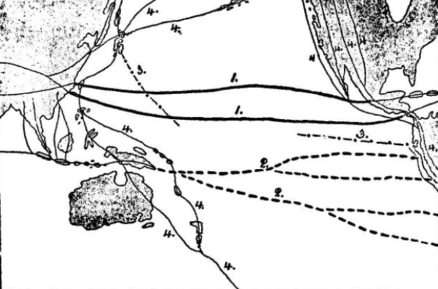
Fig. C
Fig. C
Probable Position of Gas Chambers underlying Mu before Her
Submersion

Fig. D

Fig. D
Present Gas Belts Across and Around the Pacific Ocean.
1.
Great central gas belt.
2. South Pacific cross belts.
3. Japanese-Ladrone
belt.
4. Great Pacific circuit belt.
Fig. C shows a series of chambers, O [2] corresponding with O [2] in Cuts A and B. These are connected with each other by fissures and passageways.
Fig. D shows the principal gas belts that now run under and around the Pacific Ocean.
During the forging of the belts, Chambers IO, Fig. B, became overcompressed, causing cracks and fissures in the rocks above. Then the gases entered Chambers O [1], where the same situation developed, and from there they escaped into Chambers O [2]. When this happened, the roofs of Chambers O [2] were punctured, the gases escaped, the land crashed down to the floors of the chambers, the waters of the Pacific flowed over and Mu was no more.
It is my belief that the supporting chambers which upheld Mu were very near the surface of the land. I base this opinion on the depths of the Pacific Ocean, the Troano Manuscript, the Codex Cartesianus and the Lhasa Record.
None of these records speaks of the land
having been raised to any great height before sinking into the
Pacific.
They do say, however, that,
"the land was rended and torn to pieces""quivering like the leaves of a tree in a storm""rising and falling like the waves of the ocean""during the night went down"
All of which would indicate that no great elevation of land
took place, which would have been the case had the sustaining
chambers been deep down.
From the fact that the records say that Mu
was "twice upheaved," "twice kicked from her foundations," it may be
taken for granted that another or second series of isolated chambers
lay below those supporting Mu, as shown in O1 and O2.
The first
upheaval was when the gases entered O1 from IO and the second was
when O1 broke into O2.
That the chambers sustaining Mu were near the surface and not deep down is proved by the fact that had they been deep down, the land would have been sufficiently thick to form retaining angles to uphold it after it had been raised like our mountain ranges.
Lands and continents have thus been submerged since the beginning of time. We have instances of this through the pre-Cambrian Times, the Paleozoic Time, the Mesozoic and Cenozoic Times, through the Pleistocene Period, and down, in fact, to the very edge of history.
This elimination of gas chambers and the resultant submersion of
lands went on until a sufficient thickness of the primary rock was
effected to permit of the rocks forming retaining angles when they
were lifted, thus opening huge tunnels between continuous chambers
and forming belts. When these gas belts were formed and completed it
practically put an end to this destructive submersion of land.
It is geologically certain that the gas chambers which upheld Mu were eliminated during the forging of the Pacific division of the great central gas belt and the Pacific cross belts with their many ramifications. From the presence of certain geological phenomena I have thus come to the conclusion that it was a series of chambers that underlay and upheld Mu, and not one huge chamber, as was the case with Atlantis.
It is geologically certain that the gas chambers which upheld Mu were eliminated during the forging of the Pacific division of the great central gas belt and the Pacific cross belts with their many ramifications. From the presence of certain geological phenomena I have thus come to the conclusion that it was a series of chambers that underlay and upheld Mu, and not one huge chamber, as was the case with Atlantis.
I base this belief on the following evidence:
1. The difference in the depths of the Pacific Ocean between the various groups of islands shows that with each varying depth there was a different chamber, or one chamber under another that was eliminated. Had there been only one chamber the bottom of the Pacific Ocean would be comparatively level.
2. We find that certain islands were once parts of the continent. Had there been only one chamber these could not have remained above water.
3. These islands lay over the passageways between the chambers and not over the chambers themselves. As there was no chamber beneath them they did not go down.
4. That the chambers were connected is shown by the islands, revealing volcanic workings. The gases worked under them from chamber to chamber. This naturally changed their contour and they became mountainous and jagged.
My remarks on this subject are based upon careful investigations and
observations on volcanic disturbances reported in the Pacific during
the last fifty years.
The islands and their characteristics have
also been taken into consideration. There appear to be two main
belts with many cross belts and ramifications. It is not only
possible but probable that other ramifications exist which I have
not shown. In fact, I believe there are, but I have never been able
to define them.
But how, will probably be asked, does this affect the story of Mu? If the reader will go back he will recall that, in a previous chapter describing the destruction of Mu, it was shown how these treacherous gas belts were the direct cause of the submersion which sent the Motherland of Man down in an abyss of scorching flames and rushing waters. There is no question in my mind but that the land of Mu was upheld by a series of upper isolated gas chambers, marked in the diagrams Oa.
But how, will probably be asked, does this affect the story of Mu? If the reader will go back he will recall that, in a previous chapter describing the destruction of Mu, it was shown how these treacherous gas belts were the direct cause of the submersion which sent the Motherland of Man down in an abyss of scorching flames and rushing waters. There is no question in my mind but that the land of Mu was upheld by a series of upper isolated gas chambers, marked in the diagrams Oa.
These gas chambers were the final assassins of Mu.
The exact location, area and height of each chamber is unknown. On surmise, based upon the positions of the islands, I have given the location of several of these chambers. I do not presume to say that they are absolutely correct in all minute details, but they do show the honeycombed condition of the rocks directly under Mu and the shallow depths of many parts of the Pacific Ocean show that they were near the surface.
As a geological proposition, my next step will be to note a few of the many large extinct volcanoes that are to be found among the Polynesian Islands. Up to the present time, nowhere upon the face of the earth are to be found evidences of volcanic outbursts equal to those found in Polynesia. These tremendous gaping mouths bear evidence of the compressed forces deep down within the earth's core that finally became unleashed and burst forth with a fury of destruction unequaled in the history of the world.
Kilauea is an extinct volcano on one of the Hawaiian Islands, the crater of which measures three miles in diameter. Imagine a mouth of this size taxed to fullest capacity suddenly vomiting forth its destructive fire, smoke and lava! A flood of fire, smoke and lava three miles in diameter! To what height did it ascend? Without doubt, thousands of feet, when we consider the tremendous motive power behind it.
Awe-inspiring as Kilauea was, there were probably others still larger.
This appears to be a certainty when the following facts are
considered:
The size of the chamber that was being emptied of gases, the immeasurable quantities of gases in the chamber, the force exerted by the overcompressed gases forming the belt, and the weight of the land above that rested on them and which finally forced them through the craters and released the demons of destruction that sprang at the throat of Mu and throttled her.
Taking these facts into consideration, there is little cause for
astonishment at the size of the extinct craters of Polynesia.
The
only astonishment is that there are any craters at all. With such
forces working underneath the land, one wonders why the earth was
not hurled into the sky by one mighty blast and dissolved like mist
instead of being punctured and checkerboarded with volcanoes.
When the northern main division of the great central gas belt was completed through the Pacific, a safety valve was formed to take care of future accumulations of the belt in this section. A new crater pierced through the center of Kilauea. This new crater is only 300 yards in diameter and is called Halemaumau. While Halemaumau is only one-eighteenth of the diameter of Kilauea, it nevertheless ranks among the largest craters of today and gives an idea, by comparison, of the enormity of its predecessor.
The northern main Pacific division of the great central gas belt runs directly under the Hawaiian Islands. At the Hawaiian Islands it is nearer to the surface than at any other point along its whole course, which encircles the central part of the earth.
The Niuafou is another famous crater that is of interest to the archaeologist. Niuafou is a small island to the northeast of the Fiji Islands, nearly midway between Fiji and Samoa. The Niuafou extinct crater is two miles in diameter. Since the time it helped in the work of submerging the land of Mu it has filled up with water and now forms a lake.
The foregoing are only conspicuous examples of the many immense extinct volcanoes found among the Polynesian Islands. We doubt if anything in the nature of volcanic disturbances has ever before or since in the earth's history happened that would compare in horror to the appalling cataclysm that befell the race of man when these volcanic workings blew off the lid of the earth and destroyed the land of Mu.
Geology tells us that the western shores of North America were once raised. Geology has ever been guilty of putting the cart before the horse and this is one more instance. Instead of the western shores of North America having been raised and the shore line thus extended, it was, as a matter of fact, the lowering of the level of the Pacific Ocean that extended the shore lines.
The land of Mu was an immense continent covering nearly one-half of the Pacific Ocean. In some places the ocean went down thousands of feet. In order to fill up this vast hole, which was from 5000 to 6000 miles long and at least 2000 or 3000 miles broad, to the present depths of the ocean, the surrounding waters had to be drawn upon.
To have maintained the original level of the Pacific Ocean
after Mu went down, twice as much water would have been required as
was then contained in the whole of the ocean.
This could not be
possible except by drawing the waters from surrounding areas and
shores, and when this was done there was still not enough water to
bring the ocean up to its original level. Mu was not the only land
that went down into the Pacific Ocean. An immense northern area was
also submerged, and also a smaller area to the west.
It may be asked: How did it happen that the waters of the Atlantic Ocean did not flow around Cape Horn into the Pacific Ocean and thus level off the waters again without drawing them away from surrounding shores? In answer to this I say that the Atlantic Ocean had its own troubles to attend to during this period of the earth's history as the following list of submerged lands will show:
The land of Mu in the Pacific Ocean, which was several thousands of miles long and thousands of miles wide.
The Bering land bridge in the north Pacific Ocean, connecting America with Asia. This bridge was not the narrow strip of land assigned to it by geology. Its southern shore line ran from Alaska to Kamchatka by way of the Aleutian Islands.
Its northern shore I am
unable to trace, but it was in the Arctic Ocean.
This submerged land has furnished scientists with a scapegoat to account for all the unaccountable things in America. Whenever anything has come up that could not be understood by the scientists, and that is quite frequent, it was always agreeably settled among themselves that it undoubtedly came to America from Asia by way of the Bering land bridge. Why Asia should have been selected to account for what is unaccountable I cannot imagine except that, as nothing is known about eastern Asia, there was no fear of contradiction.
Then there are the Pacific minor submersions. A stretch of land running down from California to the northwest corner of Colombia went down. This, apparently, was a narrow strip. Land was also submerged where the Malay Archipelago now stands, but the extent of this land is not known.
Atlantis was situated in the center of the Atlantic Ocean. It was an immense continental island, and at the time of its submersion it was the center of the earth's civilization.
Then there was the overland route to Europe, in the north Atlantic Ocean. This was land between America and Greenland, and Greenland and Norway, together with a great, triangular piece whose western line ran from Iceland to Cape Finisterre in the northwest corner of France.
A small area of land also went down off the coasts of Central America, which before submersion was a part of the mainland.
All of these submersions were caused by the volcanic workings during the forging of the gas belts. The great central belt submerged Mu and Atlantis. The Pacific circuit belt submerged the Bering land bridge. The Appalachian-Iceland-Scandinavian belt submerged the overland route to Europe.
By the lowering of the levels of the ocean, many lands emerged from the water, and the shore lines of remaining lands were extended.
Apparently all these great areas of land were thickly peopled, so that the loss of life was appalling. Without doubt hundreds of millions perished. Mu, alone, accounted for 64,000,000.
This geological cycle is a complete confirmation of all the data previously furnished about the land of Mu. It provides the connection that might be termed a missing link. Geologically, it proves beyond question the existence of a great prehistoric continent of land in the Pacific Ocean.
Much of the present elevation of the islands of the Pacific Ocean is due to the lowering of the ocean's level.
I have made a somewhat rough calculation as to how much the earth's diameter has been reduced by the blowing out of gas chambers and the compacting of the rocks, and find that it totals between 17 and 21 miles.
THE GREAT CENTRAL GAS BELT
by James Churchward
from
The Children of Mu
On the map below, I
have shown The 'Great Central Gas Belt' as it runs from
Mu, the Motherland to Asia Minor. After passing under Mu
in two parallels or divisions, it proceeds in an
easterly direction under the Pacific Ocean until it
reaches Yucatan and Central America.
Both divisions
split up into parallels before passing under America.
The Northern passes under Yucatan, the Southern under
Guatemala and Honduras. From America they pass out under
the West India Islands. Here the parallels close in
together again and form two trunk lines.
The Northern
division passes under the Atlantic Ocean to the Azores.
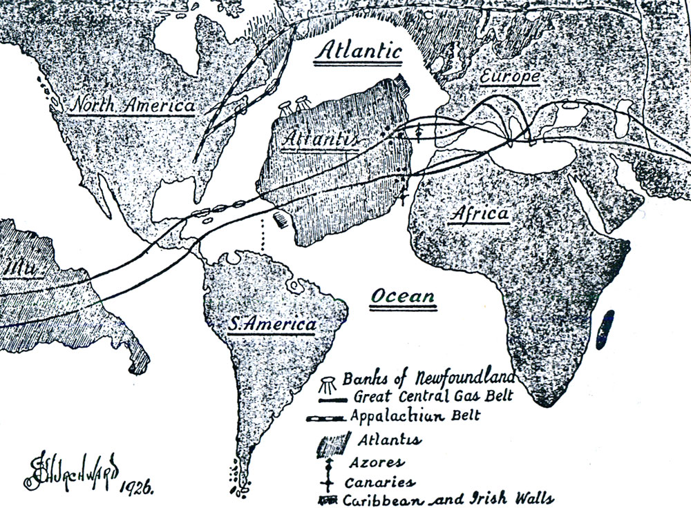
There it splits
into several parallels. Leaving the Azores these
parallels pass on and enter Europe under Spain and
Portugal.
From the West India
Islands the Southern division proceeds under the
Atlantic until it reaches the Canary Islands, here it
splits into parallels and enters Africa near Morocco,
forming the Atlas Mountains.
The two divisions of the Great Central Belt were not forged at the same time, the Southern was formed later than the Northern. Neither are they at the same depth from the surface of the earth. The Southern is thousands of feet further down in the bowels of the earth and possibly miles.
This difference in
their depth is confirmed by the fact that when Atlantis
was first submerged she only went down deep enough to be
awash at low tide so that at low tide mud banks appeared
with masses of seaweed which made the Northern Atlantic
Ocean impassable to shipping. This fact is recorded in
the temple histories of Egypt. It was only after the
Southern division had been forged, which sank her to her
present level, that ships could again cross the
Atlantic.
Atlantis was in some respects in a similar position to Mu, both lands were being upheld above water by isolated gas chambers, both lay over the pathway of a forming belt. In both cases the isolated chambers were tapped by the forming belt and blown out, in both cases the land went down and was submerged, and, strange to say, the same belt was the double assassin.
From the fact that this great belt was formed where it is and the land above submerged we gather that there must have been a great depth of rock, free of chambers, between the chambers which helped to form the belt, and the isolated chambers which were upholding Atlantis and the Land of Mu.
Had chambers
existed between the belt chambers and the isolated ones
above, these continental lands would have been submerged
thousands of years before. Had no isolated chambers been
upholding Mu and Atlantis, there would have been a
sufficient thickness of rock over the belt to have
formed retaining angles when the gases escaped after
uplifting the land.
Then these
continents would not have been submerged; instead,
mountain ranges would have been raised upon them.
From a geological standpoint there is no date shown when Atlantis was submerged except that it went down when the Great Central Gas Belt was formed under the North Atlantic Ocean. But what geology lacks, history provides and shows us that Atlantis first went down to awash 9500 B. C. and subsequently to where she lies today, Atlantis was a large continent and ultimately went down thousands of feet below the surface of the water. By her sinking an equally big hole was made in the waters in the center of the North Atlantic.
The surrounding
water flowed in to fill up this hole, which drew off the
water from surrounding shores and from all shallow parts
be. cause a new lower level to the ocean was formed.
Somewhere about this time in the earth's history the
Appalachian-Iceland-Scandinavian Belt was formed.
This belt commences
in the Eastern Southern States, rum up through Labrador
in Canada, from Labrador it passes under the Ocean to
Greenland, Greenland to Iceland, and Iceland to Northern
Europe, then to the Ural Mountains, This belt has an
immense number of ramifications.
The main belt is
shown on the map as a broken line. Before this belt was
formed there was no break in the land between America
and Europe. They were connected by the submerged land
shown in a shading and marked A, B and C. This land is
geologically known as "The Overland Route to Europe."
During the forging
of this belt the land bridge was broken up and parts of
it submerged.
The submergence of Atlantis and the "Overland Route" affected, by extension, the coast lines of Eastern America, Western Europe and Northwest Africa.
The extension of
these coast lines was due to the lowering of the level
of the Atlantic Ocean, by taking the water to fill in
the abysses made by the sinking of Atlantis and the
Overland Route. Not only were the shore lines extended,
but where the water was shallow it was drawn off and the
land emerged. Does geology confirm this statement?
It certainly does
and as prominent examples I will call attention to:
I have said that
geology confirms my statements, so it does but in a
reverse way. Poor old geology, it has ever been guilty
of putting the cart before the horse. Geology is all
right but only hitched up the wrong way.
Geology records,
"a general rise of the Atlantic Coast Line of North America during a recent period in the earth's history, also similar phenomena on the West Coast of North America."
Geologists have
apparently based these opinions on the many marine
beaches found inland in Eastern North America. These
have been geologically called Champlain beaches. In
Europe similar phenomena are found. The geological
Champlain Period is a part of the Pleistocene.
It was during the
Pleistocene that the gas belts were formed and mountains
raised and the great submersions of land took place,
many stretches of land emerging which had been in
shallow water. When geology states that the present
elevations of the Champlain beaches are solely due to
the raising of the land, geology is in error.
Their present
positions are due to the work of two agencies: the first
was the lowering of the level of the oceans, the second
was volcanic workings elevating lands in the formation
of the gas belt.